
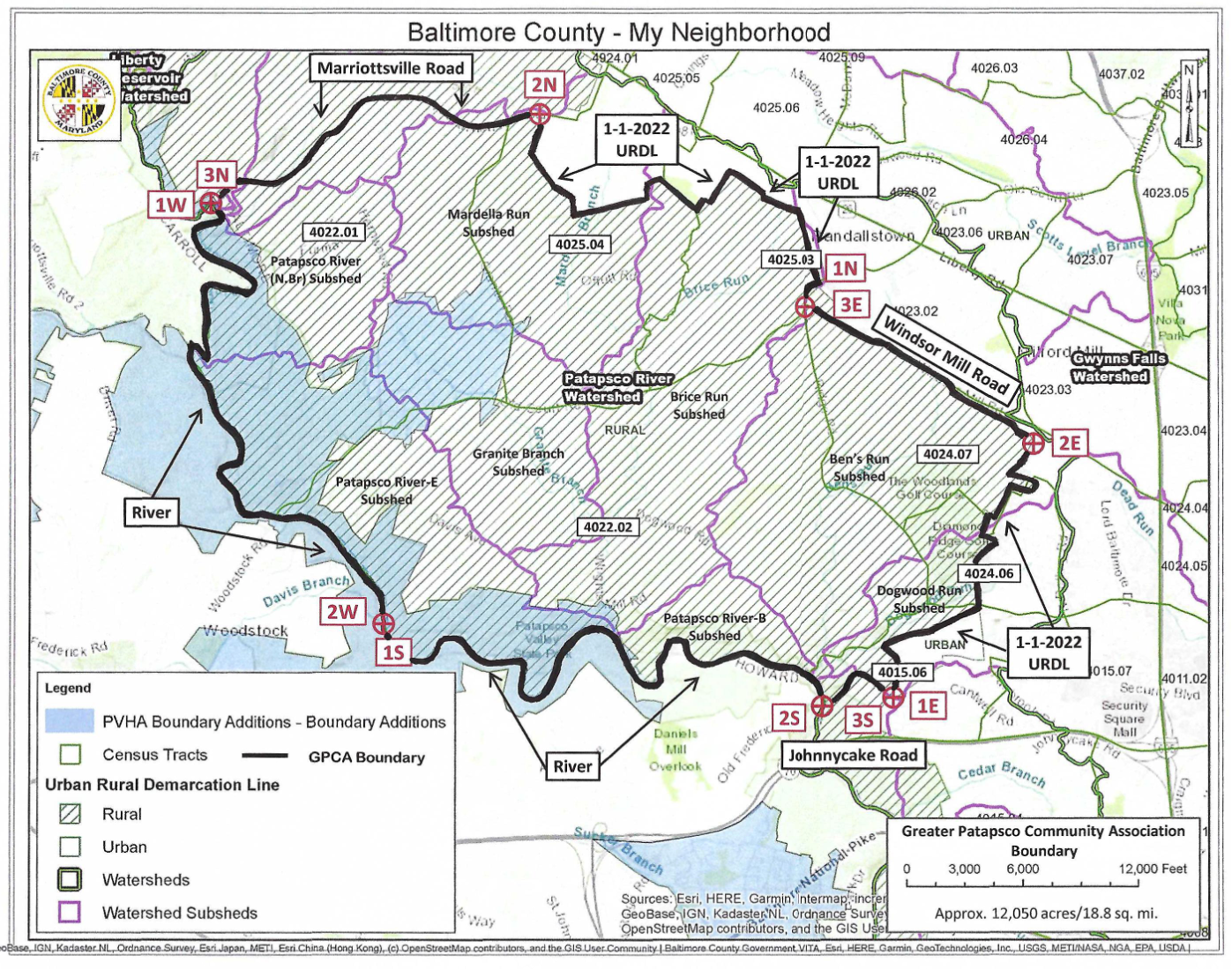
The boundary that shall set forth and determine the area included in and represented by the Greater Patapsco Community Association, Inc. is as follows with reference to longitude/latitude:
Bounding the North/Northwest (1N, 2N, 3N)
Beginning at the point of intersection at Windsor Mill Road with Old Court Road (-76.795°, 39.335°), extending along Old Court Road to the urban/rural point boundary just before Greens Lane (-76.793°, 39.357°), running along the urban/rural point boundary through Brice Run and Mardella Run Subsheds to the point of -76.833°/39.376° at Marriottsville Road (between Granite Road and Kings Point Road), running along Marriottsville Road to the Patapsco River;
Bounding the West (1W, 2W)
Running along the Patapsco River to the point at which the Davis Branch from Howard County meets the Patapsco River at -76.855°/39.320°;
Bounding the South (1S, 2S, 3S)
Running from the Patapsco River point at -76.855°/39.320° to the intersection of Hollofield Road and Johnnycake Road, running along Johnnycake Road to the urban/rural point at – 76.783°/39.312°;
Bounding the East (1E,2E,3E)
Running north through Dogwood Run Subshed along the urban boundary to urban/rural point -76.782°/39.316° (near Parton Road) along the urban boundary to urban/rural point – 76.784°/39.317° along the urban boundary to urban/rural point -76.770°/39.321° (near Clarity Court) then following the rural boundary to urban/rural point -76.768°/39.329° (near Fairbrook Road and Tudsbury) following the rural boundary to urban/rural point – 76.770°/39.330° (near Diamond Ridge Road), through Ben’s Run Subshed following the rural boundary to urban/rural point -76.763°/39.340° (near Windsor Mill Road) running along the urban/rural point boundary line parallel to Windsor Mill Road, running along Windsor Mill Road to the intersection with Old Court Road.
The enclosed GPCA boundary represents 12,050 acres or 18.8 sq. mi.
To the extent that the Baltimore County Urban Rural Demarcation Line (URDL) is used as reference, it is the URDL as of 01/01/2022.
The map of the aforestated boundary for the Greater Patapsco Community Association, Inc. is included in its definition and is attached hereto as Exhibit 1.